

Maemo Mapper v2.6.2-os2006-os2007
Stable Quality
Downloads: 15803
Votes: 23
Free & Open Source license
Votes: 23
Free & Open Source license
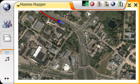
Maemo Mapper is geographical mapping visualization software specifically designed for the Maemo platform and the Nokia 770/N800/N810 form factor. It uses raster maps downloaded from the internet from various online repositories (such as OpenStreetMap). It supports tracking, routing, POI, and other features found in personal navigation devices.
Maemo Mapper is free and open source software. If you appreciate Maemo Mapper, consider donating at http://www.gnuite.com/nokia770/maemo-mapper
Updated 2009-03-15 03:45 UTC
| Author | John Costigan |
|---|
Links
Changes in version 2.6.2-os2006-os2007
This is a minor bugfix release, which also adds formal support for a couple new languages. Also added the ability to enable/disable recording of your track.
Also available for:


Comments
Perfect! On my last journey mapper ran for 16 hours in a row (without restarting) and recorded a 1300 km long track. I was adding several POIs as well. At the end saving took some time, but the sw was stable. I just love it!
Comments:
You must be logged in to make comments.