

Maemo Mapper v2.6.2-os2008
Stable Quality
Downloads: 169798
Votes: 129
Free & Open Source license
Votes: 129
Free & Open Source license
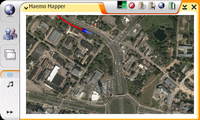
Maemo Mapper is geographical mapping visualization software specifically designed for the Maemo platform and the Nokia 770/N800/N810 form factor. It uses raster maps downloaded from the internet from various online repositories (such as OpenStreetMap). It supports tracking, routing, POI, and other features found in personal navigation devices.
Maemo Mapper is free and open source software. If you appreciate Maemo Mapper, consider donating at http://www.gnuite.com/nokia770/maemo-mapper
Updated 2009-03-15 05:45 UTC
| Author | John Costigan |
|---|
Links
Changes in version 2.6.2-os2008
This is a minor bugfix release, which also adds formal support for a couple new languages. Also added the ability to enable/disable recording of your track.
Also available for:


Comments
I can't get any routes or addresses to download on my n810 w/ Diablo.
gnite.com seems to been down for over a month are there any fixes in works
Is anybody else having trouble accessing gnite.com?
Greap application. I use it much for walking navigation. It uses open database format for storing maps, so it is possible to download maps on PC. Also, different providers can be added, including Google Maps, Open Street Mapps and Yandex Maps (russian)
@grelvis sivlerg On Twitter, @mardy says it's coming soon.
why the maemo mapper is not ready for nokia N900,,maemo5,,e ipossible instaling,thet alpication,,,why???,,pls I need help
grat app, but I want to know why the map tile where i am is now in blank. my whole city is shown when the zoom is out (zoom 10)but if i zoom in the zone is blank, and I can only see my city´s outskirts. thanks in advance if anyone can help me.
One of the best GIS apps out there, commercial or free. It keeps my N800 relevant, even as Freemantle takes the limelight.
I've been using it for 1 year 1/2, it's stable, easy to use, quick and with OSM cached I am never lost ! Very nice work.
great piece of software! awsome, just awesome
Still the best mapping software for the tablet
The application in the sense of amount of use cases make five stars, but the UI forces me to take away two stars... It's super to be able to carry "cached OSM" (or whatever) in your pocket, offline, but using the application just requires a stylus or keyboard (besides the global problem of not being able to push menu button when lid is closed - fixed in N900, thankfully) makes it pretty much set-up-and-watch -type of application. And, it just might be me, but the SQLite backend seems slower... Might just be me using external memory card...
I hope we have this N900'lized, or perhaps even a sibling project!
It works and is useable, so thx for this project. Raster maps however are much bigger than vector maps, therefore offline usage is limited to smaller areas.
很好 很强大
THE tablet application, probably the most recognizable killer app. QMapper is also good if you don't mind the loss of a few functions for a better, more polished look.
Best app on N810, but the User Guide needs to be read. The GUI is not intuitive...
Hello,
i think this tool is great. But i also have some questions? Are Marco Polo Grosser Reiseplaner Maps supported? When i select Germany as map/area to download and i choose the detail level 3 (i think the best for car in navigation) then the map is about 300 GB big.? Why are the maps so big? I can download german maps of OSM for navit. And there are about 200 MB big.. What is my mistake? Does anybody has experience with downloading maps especially for navigation? Is it right that you are not able to calculate a route offline with maemo mapper. You have to download the specified route?
Thanks very much for your answers!..
Greetz
One of the best moving app applications I've ever seen! (and also the first one I've ever used on a handheld, quite impressive).
Great app, I hope it will be ported to Fremantle, despite the commercial map applications that Fremantle may have.
The best N810 application, apart from the browser. Some of the dialogs are a bit complex, but the functionality is astounding.
When I open MM, I get a screen that says"Failed to open map database for repository: file is encrypted or is not a database Downloaded maps will not be cached. "OK'ing this screen brings up another, with "Failed to open map database for repository Downloaded maps will not be cached." Can someone interpret? Worked fine before OS upgrade.
One of the half-dozen applications that I use all the time. Key feature is the ability to download maps when you're connected then go and navigate yourself around when you're not connected.
The program falls down in its complexity and lack of tips. It took me some weeks to begin using the program at all and even now after one year I don't know what a lot of the functions do.
It's also overly complicated for simple tasks. Showing your GPS position involves a hell of a lot of control with the pointer - difficult when you're bouncing up and down on the Karakoram. Changing maps and adding/viewing Points of Interest should also be easier.
Also panning is difficult: it's too easy to lose your position completely when you're just attempting to pan the screen incrementally.
Also I'd appreciate options for deleting downloaded maps that I'm not going to use again.
Simply indispensable.
Very useful and FREE! Works worldwide without any additional costs. One of the best maemo applications which I have.
Very useful application! Thanks.
Maemo mapper + OSM saved my ass during a recent business trip to Guam. Garmin had no commercial product for the island!
Best program - 12 stars. Please, oh, please make it work with free NOAA marine raster charts from: http://ocsdata.ncd.noaa.gov/ChartServerV2.0/jsp/index.jsp?type=BSB They are even free and legal! Please, please?...(c; Do it for the sailors in the fog!
Essential for everyones tablet.
Absolute killer app!
Love it.
The most important app for me.
Excellent. Without a doubt my favorite program for my N800, especially since the latest update which sped up the tile loading-times greatly.
It's shortfall is of course the massive size of the map repository: hundreds of gigabytes. Unless you carefully plan journeys (which I recommend under any circumstance), you might find your GPS places you squarely in a big blur of pixels. It would be nice to have a small, reliable base map I think.
Another feature I'd like to see is the loading of tiles outside the screen area to give the illusion of seamless scrolling, like on google maps.
Otherwise, smashing job! Keep it up!
I have a love and hate relationship with Maemo Mapper. I adore it because it's bloody fantastic to be able to carry around street-level road, sat and hybrid maps of anywhere on the planet. Without question, it's a killer app for Nokia Internet Tablets and it's clear a lot of blood, sweat and tears went into it.
That said, I can't count the hours I've squandered trying to get seemingly straightforward Maemo Mapper functionality to actually work as advertised. Primarily this is in the realms of importing and exporting GPX data files, which it simply isn't terribly good at. Due to the application's extremely limited support for the GPX format, trying to load the vast majority of geolocalised data available online will result in the dreaded 'Error parsing GPX file.'
Though it is possible - with some difficulty - to hack away at perfectly valid GPX files until at long last Maemo Mapper will deign to import them properly, the effort can be a bit soul-destroying. Considering how well most of the other features of this app work, it's a shame that it's impossible to simply grab promising routes, geocaching waypoints or POI databases off the Net and fire them up in Maemo Mapper.
All told, a fantastic piece of software with a few vexing facets. Keep up the good work!
This application is a must have!
One of the best programs for maemo and my personal favorit!
On of the best programs for maemo. My personal favorit.
Comments:
You must be logged in to make comments.